Our Watershed SpecialistThe goals of our Watershed Specialist are to provide technical assistance to watershed organizations, help new organizations to form, assess the quality of local watersheds, aid in developing preservation and restoration plans, and educate the community about the importance of watershed conservation. Activities the Watershed Specialist may be involved include riparian corridors, stormwater management, floodplain management, wellhead protection, source water protection, water resource planning, groundwater protection, acid mine drainage, and wetland restoration. For questions or to request technical assistance, please contact: Bailey Kozalla Watershed Specialist (814) 676-2832 ext. 2 [email protected] |
Watershed Conservation Program Watersheds of Venango County Watersheds of Venango County
Venango County contains 1,365 miles of streams. About 233 miles or 17.1% of Venango County's streams are considered impaired. Nonpoint source pollution - or pollution that cannot be traced to a single source - are a major cause of stream impairments. Our Watershed Conservation Program focuses on protecting healthy streams and restoring impaired streams.
Our Watershed Specialist coordinates the Venango County Watershed Conservation Program. As a technical resource, the Watershed Specialist can assist landowners in Venango County - including private individuals, municipalities, schools, and businesses - with watershed-related problem solving. Ultimately, this assistance often results in the procurement of grants to help fund projects including:
|
What is a Watershed?
 Image Source: Seacoast Science Center
A watershed is an area of land that channels rainfall and snowmelt into a single point such as a river, stream, lake, or wetland. They are connected to almost every environmental issue we face. When pollutants can be traced to a single source, this is called point-source pollution. Examples of these include factory discharge pipes that release waste into waterways or smokestacks that release harmful gases into the air. When pollution cannot be traced back to a single source, it is known as nonpoint source pollution. This includes any pollution that is diffused across the watershed and enters streams, rivers, lakes, groundwater sources, and others. Examples of these include nutrients from agriculture runoff, erosion and sedimentation from streambanks or construction sites, and abandoned mine drainage.
Everyone on Earth lives in a watershed. Similar to a home address, watersheds are classified by Hydrologic Unit Codes (HUC) which classifies hydrologic land features into a standard framework. These categories include Region, Subregion, Basin, Subbasin, Watershed, and Subwatershed. The length of the hydrologic unit code determines the watershed's category. For example, a HUC-8 watershed - or a subbasin - has an eight-digit code. The name of the watershed is often determined by the name or section of the river that is the largest flowing waterbody.
Venango County is located in the Ohio River Basin and is composed of 9 major (HUC-10) watersheds. These include the Allegheny River, East Sandy Creek, Oil Creek, Pine Creek, Sandy Creek, French Creek, Sugar Creek, Slippery Rock Creek, and Wolf Creek watersheds.
Watershed Partners
The Venango Conservation District's Watershed Conservation Program partners with local watershed organizations to implement preservation and restoration measures to conserve the water resources of our county. The passionate volunteers in these organizations work in cooperation with our district by sharing resources and partnering on projects that serve a variety of benefits to landowners, businesses, ecosystems, and the public.
Stormwater Solutions to Nonpoint Source PollutionBelow are small-scale, yet very useful stormwater management practices that homeowners and businesses can utilize. Contact the Watershed Specialist for more information or for assistance related to these projects.
 Source: Lincoln Stormwater Program Source: Lincoln Stormwater Program
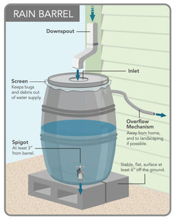
Rain Barrels
The average household uses 146,000 gallons of water per year. Up to half of that is used just for watering landscaping during the summer. By collecting rain water you can save energy, water and money while helping keep our streams clean by reducing runoff and erosion. Stormwater runoff picks up pollutants such as soil, lawn fertilizers, pesticides, trash, animal waste, road salts, chemicals, etc. and transports them to waterways. Increased amounts of stormwater runoff also increases erosion and flooding. Capturing some of the water will reduce velocity and peak flows. With a rain barrel, you can collect rainwater from your gutter downspout and use it around your home and garden, which means spending less on your water bills. It should not be used for human consumption. 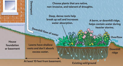 Source: Philadelphia Water Department Source: Philadelphia Water Department
Rain Gardens
A rain garden is a depressed area containing grasses and flowing perennials that collects rain water from a roof, driveway or street and allows it to soak into the ground. It can be a cost effective and beautiful way to reduce runoff from your property by filtering out pollutants in runoff and providing food and shelter for butterflies, song birds and other wildlife. Rain gardens capture the rain that would usually runoff your property and allow it to soak into the ground. The native plants in the garden filter contaminated water that would normally wash into storm drains and eventually into our water supply. Compared to a patch of lawn, a rain garden allows about 30% more rain water to filter into the ground. Rather than a traditional raised garden bed, a rain garden is a sunken garden. They should be placed at least 10 feet from the house and on a gentle slope that catches downspout water. A ponding area is created and layers of gravel, sand, and a soil/sand mix are added. Then, native perennials are planted. |
Pond InformationWe can offer technical assistance related to pond maintenance by offering recommendations regarding aquatic plant and fish species management. If you have questions or concerns about your pond or are planning to build a pond, contact the Watershed Specialist for more information.
Permits for pond construction and/or disturbance activities may be required under the PA Dept. of Environmental Protection's Chapter 105 (Dam Safety & Waterway Management) regulations. Our office can assist you in determining which permits apply to your project. 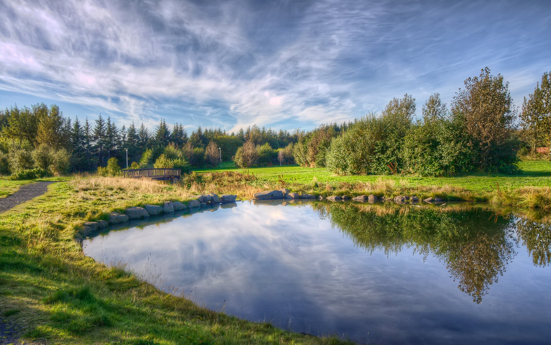
|
Maps
Check out these maps showing different attributes of surface waters (streams & lakes) in Venango County. Click on a map to download a PDF version.
